Surveillance:
Geopolitical Maps & Reference Atlases

Political maps and reference atlases for keeping the geography straight. Check the edition before treating a border as current.

Evaluate

Sponsorship confirmed.

Optimizing Border Surveillance with Energy-Efficient Wireless Sensor Networks
Jul 23, 2026
Optimizing Border Surveillance with Energy-Efficient Wireless Sensor Networks

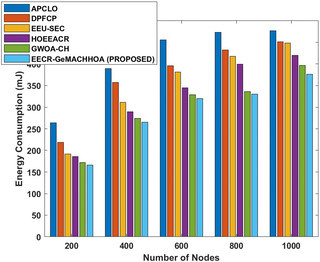
Border surveillance is crucial for national security, requiring the deployment of effective wireless sensor networks (WSNs) to monitor sensitive areas. This study introduces a new approach that combines a hybrid energy-efficient zone-based dynamic clustering method with routing, utilizing the Geometric Modified Ant colony Harris Hawk Optimization Algorithm (EECR-GeMACHHOA). The goal is to enhance energy efficiency and extend the network's lifespan. The method begins by identifying zone monitors through geometric translational symmetry, forming optimized zones that utilize a modified ant colony for selecting multiple cluster heads. This approach improves routing pathways by integrating geometric and nature-inspired optimization techniques, resulting in reduced energy consumption and increased packet transmission rates. The study reports a 6.66% reduction in network latency, a 15.03% decrease in energy usage, and a 9.86% increase in packets sent to the base station compared to alternative methods. The findings highlight a significant improvement in network lifetime and data transmission reliability over contemporary strategies. WSNs are particularly suited for border surveillance due to their ability to monitor vast areas and transmit data in real-time. However, challenges such as limited battery capacity and energy consumption can hinder their effectiveness. The proposed EECR-GeMACHHOA method addresses these issues by optimizing cluster head selection and routing, thereby balancing energy loads and minimizing communication overhead. This innovative approach not only enhances the performance of WSNs but also ensures their adaptability in dynamic environments, making it a valuable contribution to the field of border security and surveillance.

Surveillance:
Geopolitical Maps & Reference Atlases
Evaluate
Intelligence History
Evaluate
Cybersecurity Books
Evaluate

Sponsorship confirmed.

Surveillance:
Geopolitical Maps & Reference Atlases

Political maps and reference atlases for keeping the geography straight. Check the edition before treating a border as current.

Evaluate
Intelligence History

Secret operations, double agents, and the decisions left out of the official version.

Evaluate

Sponsorship confirmed.

Recommended for You
Israel's National Security Minister Calls for Arrests Over Election Allegations
Intelligence Nov 1, 2026

Israel's National Security Minister Calls for Arrests Over Election Allegations

Itamar Ben Gvir, Israel's national security minister, has made controversial claims regarding the integrity of the recent Knesset…

Surveillance:
Geopolitical Maps & Reference Atlases

Political maps and reference atlases for keeping the geography straight. Check the edition before treating a border as current.

Evaluate
Intelligence History

Secret operations, double agents, and the decisions left out of the official version.

Evaluate
Cybersecurity Books

Threats, defenses, and the human habit of clicking things we really shouldn't.

Evaluate
World Affairs Books

Diplomacy, rivalries, and the backstory behind the next international headline.

Evaluate
Intelligence Analysis & Critical Thinking

Books on evaluating evidence, testing assumptions, and building sound assessments. Confidence is not a substitute for a source.

Evaluate
Counterintelligence Case Studies

Nonfiction accounts of moles, deception, and investigations. The warning signs tend to look clearer in the final report.

Evaluate

Sponsorship confirmed.